Day 17 - Wednesday, June 20
Warm night, warm dawn, no wind
Rose and had the motorbike packed in one hour.
Drove to McMinville. Asked a fellow at gas station for the nearest diner. He stopped pumping gas, can around his truck and gave me specific directions to Lucille's. I found it easily.
Inside is a long counter, as if they serve ice cream. A plump elderly woman, hunched over, but with a great smile and gleaming white hair, said, "You just sit yourself down honey. The girl will come and wait on you." Okay. Then I saw that the custom in Lucile's is to grab your silverware, napkins, and all the condiments you anticipate using, before you sit down. Next time I'll get it right.
To move from the Smokies (or is it Smokeys? I've seen it both ways) to the North entrance of the Natchez Trace Parkway, I had to cross about 175 miles of Eastern and Central Tennessee. I had to decide between extreme zigzags like in Pennsylvania, but with far less forest, or a more direct highway. I chose the highway route. Most of it was excellent. There were four lane roads where I could do 45 and no one cared, since they could easily pass me. The two lane roads were lightly used, so that was easy too.
Geologically, central Tennessee is noticeably different from the mountainous East. All the rock formations are horizontal. They are layered sediment from eons of being underwater. This base rock is very close to the surface. The soil is very thin. However, there are sections where the old roots of the Appalachians rise up in a ridge that you must switchback up and down.
The North entrance to the Trace is near southeastern Nashville. I plotted secondary roads around the heavy traffic. I was about 80% successful, which I think was very successful. During a break in a small town, I noticed I had exceeded my mileage-fill up number and had better get gas. One hundred yards later, I ran out. I poured in my spare.
I calculated I had enough to make it to the top of the Trace, where gasoline a-plenty would be found. I rode on through farm fields with rolls and rolls of hay. No animals, but lots of hay. I made it to the Trace. I was told of a landmark restaurant at the north entrance I had to check out. It's called "Loveless Cafe". I found it. It's a major tourist attraction. It was packed.
I drove around several parking lots looking for a space. I saw only one motorcycle. It was 95 degrees. Then Moto Fabini conked out. I found a space and parked it. I decided a cool sweet ice tea was in order before I freaked out. As I said, the place was packed. It was an hour wait. I walked around sweating. I found a rocking chair and moved it under a tree for shade. Things became far more pleasant.
I was called inside. The food and the service were great. The sweet ice tea perfect. As I was sipping away it came to me the bike might just be out of gas. My spare does not fill it up100% and the drive had been long. So I decided to take a look in the tank. Sho nuf, bare as a baby's bottom. A gas station was right next door. I filled the tank and the spare, repacked the bike and headed to the Northern entrance to the Natchez Trace Parkway.
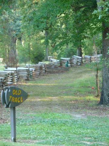
The Trace is about 450 miles long. It ends in Natchez, Mississippi. It is similar to the Blue Ridge Parkway, but it does nor run along a mountain ridge. It follows a path traveled by intrepid traders of early America. They would float their goods down the Mississippi. It was impossible to get the boats back up the river, so they would abandon them and walk back north. The trail they blazed is still evident. This highway follows it.
Like the BRP, the trace runs through pristine land. Wildlife is everywhere. The Trace is flatter and I must say, perfect for long distance bicycle riding. If you are planning a double century, this is a perfect training ground.
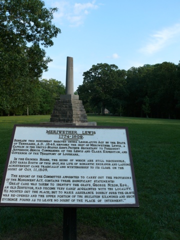
I camped at the Meriweather Lewis Campground. The reason this stop is named for the man who led the expedition to the Pacific Ocean, is because this is where he died. He was 35. He committed suicide. He's buried here.
On hearing the news, President Jefferson wrote the following:
"Of courage undaunted, possessing a firmness and perseverance of purpose which nothing but impossibilities could divert from its direction, careful as a father of those committed to his charge, yet steady in the maintenance of order and discipline, intimate with the Indian character, customs, and principles; habituated to the hunting life, guarded by exact observation of the vegetables and animals of his own country against losing time in the description of objects already possessed; honest, disinterested, liberal, of sound understanding, and a fidelity to truth so scrupulous that whatever he should report would be as certain as if seen by ourselves - with all these qualifications as if selected and implanted by nature in one body for this express purpose, I could have no hesitation in confiding the enterprise to him. To fill up the measure desired, he wanted nothing but a greater familiarity with the technical language of the natural sciences, and readiness in the astronomical observations necessary for the geography of his route. To acquire these he repaired immediately to Philadelphia, and placed himself under the tutorage of the distinguished professors of that place."


It's been fun following your progress in these notes (and photos) and with Google Earth. Unfortunately, it's been difficult to find every mentioned place name's location due to Google's lousy POI database. Would it be possible for you to drop in lat/lon coords inline with your comments so those who are interested can cut/paste them into Google Maps or Google Earth (or others)?
ReplyDeleteTed, Lat-Lon is beyond me. Plus I think it's best to keep it all fuzzy. It's all fuzzy to me in this 95 degree Mississippi heat. -J
ReplyDelete